Friday, October 2, 2015

Towns along the Road

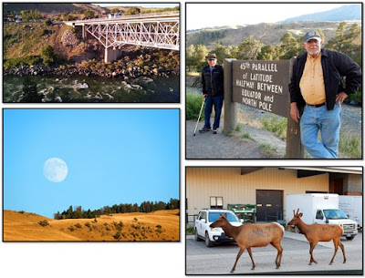
Top L to R: Bridge at Gardiner, 45th Parallel
Bottom L to R: Moon at Gardiner, Elk
Since we could not get a place to stay in Yellowstone National Park for more than two consecutive days at a time, and because we really didn’t want to pack and unpack that frequently, we stayed outside the park in the small town (pop. 875 in 2014) of Gardiner, Montana. For the tiny population, there are an amazing number of very good places to eat dinner, but a dearth of places for breakfast. While we were there, the main road was being re-paved; the rest of the streets in town are gravel. This is a busy place for travelers all year round because of Gardiner’s proximity to hunting and fishing, as well as several areas for camping and hiking and the north entrance to Yellowstone. On our morning and evening travels out of and back into town, we got to see a herd of antelope grazing next to the main drive; one evening the traffic in town was a pair of elk wandering along one of the city streets. The town of Gardiner was founded in 1880, but has been the main entrance to Yellowstone National Park since its creation in 1872. The original arch still stands and a new road will route visitors through this historic gate in another year or two. One of the oldest businesses in town is Parks' Fly Shop, begun in 1953 by Merton Parks,
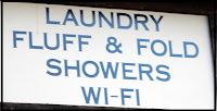
Laundry Sign
it’s just down the road from one of the newest firms, the Yellowstone National Park Heritage and Research Center. And of course, there’s the Fluff and Fold where you can get a shower, wash your clothes, and go online all at the same time. Gardiner was named for Johnson Gardner, a fur trapper who worked in the area in about 1830. He named river and the valley after himself, but a later expedition misspelled the town’s name and that name stuck. J.C. McCartney and H. R. Horr claimed land that eventually became part of Yellowstone, building a rudimentary hotel at Mammoth Hot Springs. In the late 1800s a territorial post office was established, giving an air of respectability to Gardiner and attracting the railroads. Railroad service lasted until about 1948, and work in Gardiner has focused on tourism ever since.

Original North Entrance to Yellowstone National Park


While seeing Yellowstone was fun, we did take a break from nature and went in search of
Top L to R: Decorated Traffic Boxes, Dogs
Bottom L to R: Garden of Beadin'. Stix
urban amusements. About 80 miles (129 km) northwest of Gardiner is
Bozeman, Montana. This is a really pretty city with non-tourist shopping and a historic downtown. The municipality is named for John M. Bozeman who founded the Bozeman Trail. Bozeman, with his partner John Jacobs opened this branch off the Oregon Trail to connect Bozeman with Virginia City, a mining town. Of course white hunters and trappers weren’t the first people in this area. For thousands of years the Shoshone, Nez Perce, Blackfeet, Flathead, Crow Nation and Sioux traveled through the area, calling it the ‘Valley of the Flowers’. These original residents were not thrilled with the settlers using their valley and, during the war between the US Government and the Lakota, Northern Cheyenne, and Northern Arapaho tribes, the Bozeman Trail was closed. Finally ranching and farming became well established and by the 20th century much of Gallatin Valley was planted with sweet peas. The plants grew so well that at one time the area produced about three-quarters of all the peas in the US, making Bozeman known as the ‘Sweet Pea capital of the nation’. Though I didn’t find any peas, I did locate two shops that were a lot of fun. The Garden of Beadin’ satisfied my need to enhance my ever-growing collection of glass beads, and Stix provided me with several skeins of yarn. This small city really appeals to me, especially in mid-July. From May to October, the climate in Bozeman is lovely; but the rest of the year the weather is a bit on the chilly side with temperatures averaging below freezing from November to March. I may have to come back in the winter just to convince myself that I really couldn’t live there.

At the end of our visit to Yellowstone National Park, we left through the northeast gate, visiting Cooke City only briefly. This looks like a little tourist town, but it has a diverse
Ridge near Cooke City
history. The town and the land around it were within the Crow Reservation until about 1882 when the boundary of the reservation was moved east to quell the fights between the Crow and gold miners. Plans for town growth were dashed because Congress refused to allow trains to come to the city. However, people continued to come to the area, including F.J. Williams, a primitive artist. His house and gallery were built more than 140 years ago as a rest stop for folks traveling in and around Yellowstone. Another emigrant was Vic Heyliger, Michigan Hockey Coach, and Professional Hockey player. He was concerned about the emotional, mental and physical health of young men and moved his Boy's Ranch to the Cooke City area in 1951.


The road from Cooke City heads south, taking you into Cody, Wyoming. Along the way is a wonderful drive on Chief Joseph Scenic Byway across the Absaroka Range through the
Views from Dead Indian Pass
nastily named Dead Indian Pass; Dead Indian Creek runs at the base of the pass. The road twists and turns giving you good views of surrounding mountains, valleys and streams. At the top of the pass there is information telling about the flight of the Nez Perce Indians during the Nez Perce War in 1877. Chief Joseph, leading about 700 Nez Perce men, women, and children along with 2,000 horses through Yellowstone National Park east and into the Absaroka Mountains, was being chased by General Howard and his soldiers. Searching for a way across the Absarokas and onto the Great Plains, Chief Joseph had to evade the cavalry by decoying them south. Eventually the tribe was cornered and defeated at the Battle of Bear Paw. The road out of the pass is beautiful, in a rugged way, changing from dense green forests to high desert. From the pass, it’s a relatively short drive into Cody, to the Buffalo Bill Center of the West and lunch at the Irma Hotel and Restaurant. Cody sits on the western edge of the Bighorn Basin surrounded by the Big Horn, Owl Creek, Bridger, and Absaroka mountain ranges. William F. “Buffalo Bill” Cody first saw this area when his son-in-law, Horace Boal, took him to the top of the Bighorn Mountains. Cody envisioned building a town in the area to attract tourists, ranchers and farmers. Using the Shoshone River waters for irrigation, the people in the town prospered. The railroad brought even more business, as well as more people to work in the area. Along with various enterprises, a town newspaper was established in 1896 and is still in publication. The Irma Hotel, named for Buffalo Bill’s daughter, opened
Top L to R: Cody Firearms Collection,
Daniadas Sculpture
Bottom L to R: Statue Buffalo Bill, Rough Riders Poster
November 18, 1911, and while the gambling rooms that it once boasted are gone, it still functions as a hotel and restaurant. Not too far away is Buffalo Bill Center of the West near which stands a statue of Buffalo Bill on his horse sculpted by Gertrude Vanderbilt Whitney. This is a fascinating place that had once only held Buffalo Bill memorabilia and some interesting displays about the local Native Americans. However, the museum has really grown since the 1990s and now has five wings that include extensive displays of firearms, art, tribal history, Buffalo Bill artifacts and natural history.


From Cody it’s only about 80 miles (129 km) into Thermopolis (Greek for ‘Hot City’). Even
Left: Masonic Temple, Thermopolis
Right T to B: Wind River Valley Wall,
Wind River Valley Bridge
though I’d been there once before, I didn’t know that it had the world's largest mineral hot spring as part of Hot Springs State Park. And since I was there last a private organization built the Wyoming Dinosaur Center that has on display the only Archaeopteryx fossil outside Europe. We arrived late enough in the day that we didn’t get to visit either one of these sites; there always has to be a reason to go back somewhere. About 120 miles (193 km) east of Thermopolis is the infamous Hole-in-the-Wall. Located deep in the Big Horn Mountains, the site was used by the Hole-in-the-Wall Gang, which included Kid Curry, Black Jack Ketchum, and Butch Cassidy's Wild Bunch gang. Because it was easily defended, this is the spot outlaws congregated to wait out the harsh winters. When it was in full operation, there were cabins, a livery stable, a corral, livestock, and supplies. When supplies ran low, all or part of the gang would ride into town to shop and visit the bar. As we left Thermopolis and headed toward Shoshone we were treated to one of the prettiest routes in this area: the Wind River Canyon. The roadway is, at times, level with the canyon floor offering views of the canyon walls, some as high as 2,500 feet (762 m). The north end of the canyon is at the ‘Wedding of the Waters’, where the Wind River becomes the Bighorn River. As you travel south toward the dam, it seems that you are travelling downhill, giving the impression that the river is flowing uphill. This appeared to be one of the last really pretty areas on our way home. The drive from Thermopolis to Cheyenne to Denver and finally Colorado Springs seemed to take forever; from there to Lubbock seemed longer still. Or perhaps we were simply ready to be back in Texas.


For information about What we did, Where we stayed and What we ate, go to ‘Reviews of the Road Trip to Yellowstone’.
L to R: West Texas Sunflower Fields, Windmills
©2015 NearNormal Design and Production Studio - All rights including copyright of photographs and designs, as well as intellectual rights are reserved.

No comments:

Post a Comment